mne-tools / mne-tools/mne-python
ENH topomap validation and bad channels
Nobody has claimed this yet.
- Dominant language
- Python
- Stars
- 3.5k
- Forks
- 1.6k
- Avg merge
- 1d 6h
- Merged PRs (30d)
- 100
Description
When using mne to plot topomaps computed with some external methods, it highlights a channel that appears to be "bad", in the sense that the topomap is discontinuous:
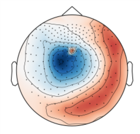
Here is a snippet reproducing this topomap with files from numpy_files.zip:
import numpy as np
import mne

pos = np.load("pos.npy")
u_hat = np.load("spatial_map.npy")

mne.viz.plot_topomap(u_hat, pos)
I would be interested in having a utility function returning the spatial regularity of a topomap and the potential bad channels. And I think it would be better in mne as you need to correctly parse the position of each sensor to compute the spatial differential.
Contributor guide
First steps
- Read the whole issue, then the project's contributing guide.
- Comment on the issue to say you are picking it up — it saves two people doing the same work.
- Fork the repository and make your change on a branch.
- Open a pull request that references the issue number.
Research direction
Start with the issue's reproducer using pos.npy, spatial_map.npy, and mne.viz.plot_topomap. Read the topomap visualization entry point and determine how sensor positions are parsed. Done should include a decided utility API that measures spatial regularity and identifies potential bad channels, with coverage for the supplied example.
Written by the indexing model from the issue text.
Assessment
- Tech stack
- numpy, python
- Domain
- data-visualization
- Issue type
- Feature
- Difficulty
- 5/5
- Estimated time
- Over a week
- Activity status
- Stale
- Clarity
- Needs clarification
- Newbie friendliness
- 30/100