valhalla_export_edges v2
- Dominant language
- C++
- Stars
- 6.2k
- Forks
- 981
- Avg merge
- 2d 14h
- Merged PRs (30d)
- 14
Description
(2016-10-17T15:12:25Z) @missinglink : originally created valhalla/tools#96
this ticket is to track issues that would improve how the `valhalla_export_edges.cc` script works in regards to the https://github.com/pelias/interpolation project.
- [ ] **break lines when `access` changes**
as per the case below, we would like to avoid using the section of the road reserved for pedestrians for address interpolation. 'cutting' the road in to two will result in more accurate interpolation for vehicles.
example: https://github.com/pelias/interpolation/issues/11
- [ ] **remove ferry routes and other non-road ways**
we're only concerned with address data, so anything which doesn't have house numbers associated to it can be removed in order to keep the export file size down.
example: http://www.openstreetmap.org/way/6644126
example: http://www.openstreetmap.org/way/430610059#map=18/40.73282/-73.98087 - there are a bunch of 'other' paths in this area including `highway:service` and `highway:footway` and also some cycle tracks just to be super confusing!
example: http://www.openstreetmap.org/way/384288970 - this one appears to be a bus stop.
- [ ] **increase the 'greediness'**
there are some linestrings which look like they could be longer, such as:
```
yt|o|Artde`FyLhCs`@vM??n^lqBlJroAsArd@eJjV_c@`r@qWzJuJhM_Ejj@rA~]fi@vm@tNhWhRfD~Np\p\dy@fDl_@pQb[zPtc@bL~|@^n]cMp{@c[fc@_]|i@qRvv@eErp@?`fArA|qAzP|rAj`@`{@nHp]gCp[yM~]yVj`@c[~]m_@jk@kp@xiAiRfOgh@vMs_@yAiw@cGcKaHc[sP}d@oTsPmIgDpQxG~I|TbPb[~]x\z`@ze@n]fg@`S`l@?~gAcGnqAaSre@?bUzAzk@b[tc@yAlJ`G\xMgD`G{UbG_NxBsUl@ucArQiM|Sm@lJxGjLfYl@jp@wDfg@dZ~b@b[xLl_@ra@`g@zUrQ|c@m@xk@}Jre@gDtJuE??l_@{U~b@eOtOrExGnTjBl^hLpRnXrQxHb[wDpRwMtYiCdYrPvXnIb\~N~]fg@dn@zGlU?dc@lIxMlZrP`MtYjQd[|TlTvNtn@tIvb@bLvNrPrPzF`SlJtYlJdZ|U|S??`MtP|DbQt@vv@|D~{AvDvMdOnTNL|JbGxk@hC??fNz@nDrGxAhVaBfc@gDhWyH`SqLpG??}DxBox@vc@sAdE?\GtEjBtDvb@gCbVhB??~XxBpRrF~RrFbk@|t@nHzUfh@bo@hXlt@v]ls@lYz~@zK~^rFl^t@lT|DhXn^n|@jKrP|ZdnATl@jBtD`BvD`M`G`RlUlJ~]bGzt@FjAlElU~Sbo@hLvc@zArFbBpGpLtYfDvDrKvM|EtFvl@jt@pzAtcA|O~RbLvXzKju@rKju@pLtn@rBhWGlTsApRyHli@yFrPqHnI}lB~fAmDxB{GvDuIjKkFdOu@hMd@bQ??zAjBxe@hk@|@jAd@l@`w@z~@h~AnrA|ZgEjy@|Jxa@sF~SxBlEpGvM~r@`IlTrF~IzJ`HtZ`HxLrFfNzKj[l_@~IbQnHz_@jLxa@hWvm@t|A~nChXdx@??vR|i@`]h`AhBjV{@jUsFlUe_@dd@aMlUoNdd@{Ar[?\dJxa@hWzj@dKvMxVrPfOjWf|@viClK|}@jAfb@eAre@gDh`B_Cha@kLz`@aMvb@wh@j_AuEfXsEhMgIbGiXnH}IdFkGzKuE~RcA~^aB`RuFbQ{PvXeJzKaRjKm_@rFkQm@}m@_TyM|@wRrFmd@pR}c@xa@eUbPck@~SwIxM_CzUWbFU~I`CpR|IdYbGr[hBjiAhHhMdO~IbGtDxLbQfDlUsAdYiWvjBcAzAcG|J_TlU}SfMiq@z`@ONi\jUqMfOoIdOk@xBwDxMqBnSiCfw@oCxLaHlJe_Afn@cUOsKeEcWo]uDyBeE_@{FxBeKdP_ItE{`@eE{e@xAeJtEcj@li@y\zK_J~HkKvYmOhW{VbQshAjj@yeAhb@ah@xKyu@|J}n@eEgI~Hyf@fx@al@rZgb@fOO?aRfN}OpQcQp\oSjVw|@xl@wl@lh@{nAfwAaq@bQaN|J}NtYsG|Is_@xWcWrF{JNs`@sFqHaHuOwX}OcRgHyB??aHyBiWk_@mE}J}@sQwCiL_ImJeFwNmEia@mOgYgNiCcB|@{FhBuI~IyMjUiCnI{@hCkA`RGpQnDd[?dc@cBzVcLfYs@dOlEvb@GrPmEfO_IdEi~BppAqg@|^{e@|Sc[`Hg]^{Q}@uJ]}DhBu@rFbBdF|Dz@fOwC~\hBbGtEvXjBtc@nIra@fCzJdFtn@tDxWeEpWkAzKzAbKnHnvA|JpHbF`HhN`CnR??u@dPGzAyBnH??{@xByHdFwH?{ViM??kPoIkG{@eTgDw]}@yiBb\md@rE{cAnTq_Bdx@iHfDgIpGav@xl@eZ~]u~@n{A??m~@byA??}N`\uEnToCvW??GnT
```
- [ ] **export all the names (including alt names)**
this is not for interpolation, it's for importing in to Pelias. since we do not link the exported data to OSM we lose the alternate names for road, and possibly translations. It would be ideal to export all versions of the names we found for each segment.
the current format allows for a `\0` separated list of names so it should 'just work' out of the box. how common are alternate names for streets/ different languages? If possible it would be nice to have the OSM tag name also, where the tag name has semantic value (such as language codes).
- [x] **deduplicate coordinates in linestring**
there appear to be duplicate adjacent lat/lon pairs when decoding the polyline format.
- [x] **configurable minimum line length**
**[edit]** marking this as completed, this can easily be done by the consumer, generally more data is better *-missinglink*
some linestrings are very short, it would be nice to be able to skip exporting them if they were under a certain threshold.
example:
```
3640618|mxhdaBkFV~E
3965397|oihr`BgaC??
10213015|w}owpAe_E]H
10213037|ucpwpAu|DTM
```
- [ ] **include private roads**
the road segment linked below is not exported, possibly due to it being labelled as pedestrian but also `vehicle:private`
example: http://www.openstreetmap.org/way/4618808#map=18/52.49653/13.36355
- [ ] **rue de rivoli**
this Parisian road is exported as several line strings, on investigation it seems like the geometry is correctly attributed in openstreetmap (names are correct).
It would be ideal if this road could be exported as a single line.
as an example, this intersection appears to be a point where the geometries are split:
- http://www.openstreetmap.org/way/294799052
- http://www.openstreetmap.org/way/25485929
- http://www.openstreetmap.org/way/192903835
- http://www.openstreetmap.org/way/192903842
**[edit]** after a second look, I think the graph traversal is correct, I think the duplicates are due to some pedestrian/cycle ways in the area with the same name.
```
uv_e|AmvonCe@nDe@zCe@lD}EnTyLtj@mFhT]nAsAxGmJxd@iLfh@_@nAyAtHcB`HkG~XgCnLgDbOuJrb@W|@iBrI{Kff@]tAm@vC_I~\qCjMUzAeAvE{Kpf@]pA{AhHiBhIoDbOM|@eAtEcAlE_Opp@UfAsAtGcFrT{L`k@U|@e@bCcB~F]fAgD|JeExOqM|m@uJrb@kAnFsj@jdC{FpWsFlVaMvi@]rAWnAsA`G]dByBpJcAbE}UbeA{@bEk[lwA}@nDk@dCeA`F{@bEcBhHUpAsBrIs@bDaCpKcA`FaSl}@sAlFmO`r@}c@drBaCdKgDlOaS`}@aQjw@u@vCsP~u@aCpTOnC?hI?vD?r@?s@?wD?iINoC`CqTrP_v@t@wC`Qkw@`Sa}@fDmO`CeK|c@erBlOar@rAmF`Sm}@bAaF`CqKr@cDrBsITqAbBiHz@cEdAaFj@eC|@oDj[mwAz@cE|UceAbAcExBqJ\eBrAaGVoA\sA`Mwi@rFmVzFqWrj@kdCjAoFtJsb@pM}m@dEyOfD}J\gAbB_Gd@cCT}@zLak@bFsTrAuGTgA~Nqp@bAmEdAuEL}@nDcOhBiIzAiH\qAzKqf@dAwET{ApCkM~H_]l@wC\uAzKgf@hBsIV}@tJsb@fDcOfCoLjG_YbBaHxAuH^oAhLgh@lJyd@rAyG\oAlFiTxLuj@|EoTd@mDd@{Cd@oDd@oD|Igo@l@uDnOodA~BmPdPafAvD{Vd@yClDuV`Iqi@r@_Fd@mDlEcZfJ}m@l@cEj@yDfJon@bAcH|@uFpG}c@tDyWvNqaAhCkQhBuMiBtMiCjQwNpaAuDxWqG|c@}@tFcAbHgJnn@k@xDm@bEgJ|m@mEbZe@lDs@~EaIpi@mDtVe@xCwDzVeP`fA_ClPoOndAm@tD}Ifo@e@nD
```
- [ ] **do not export main road refs**
I noticed that in London (possibly common throughout the UK) there are alphanumeric identifiers used to denote major road ways, eg: 'A1202' or 'B501'.
The names for these road ways are exported and when used to group ways by name, they group together roads which actually have different names.
This makes it difficult to perform grouping and results in problems with duplication and incorrect association of points for address interpolation.
An example at location `18/51.51575/-0.15543` there is this grouping of 'Portman Square' and 'Gloucester Place' because they share the `ref` of `A41`
Same issue in Germany, eg: `18/52.51617/13.38611`
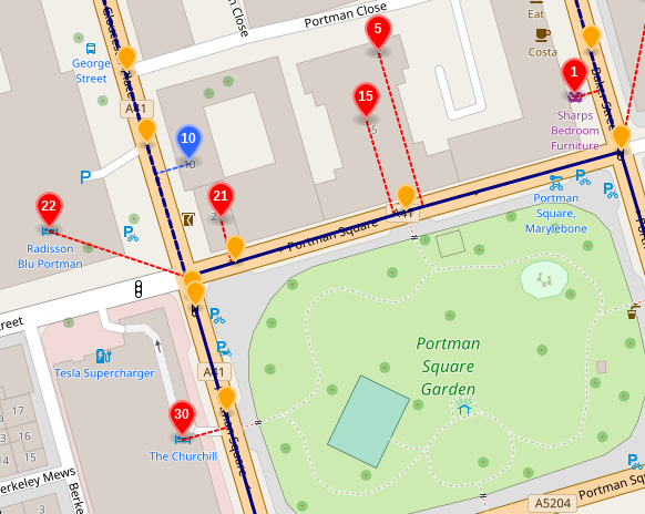
It may be as simple as excluding the `ref` tag from export, a more general-use strategy would be to give exported names a key->value syntax so the consumer could identify and discard names it felt were not applicable to it's domain.
If the `ref` values are also used to walk the graph it might be a little trickier?
eg: http://www.openstreetmap.org/way/4253840
Contributor guide
Assessment
This issue has not been assessed yet.