microsoft / microsoft/GlobalMLBuildingFootprints
many gaps that look more like processing errors
Nobody has claimed this yet.
- Dominant language
- Python
- Stars
- 2k
- Forks
- 277
- PR merge metrics
- No merged PRs in 30d
Description
Hi, I've spent some time perusing these data. And they nowhere near cover the intended areas without supplementing with old v2 building datasets.
Here's a very curious example. Take the two quadkeys covering La Paz, Bolivia.
Quadkey: 210031332 LngLatBbox(west=-68.90625, south=-16.636191878397657, east=-68.203125, north=-15.961329081596647)
Quadkey: 210031333 LngLatBbox(west=-68.203125, south=-16.636191878397657, east=-67.5, north=-15.961329081596647)
DEBUG: 761 building polygons found in quadkey 210031332
DEBUG: 224,632 building polygons found in quadkey 210031333
Notice the vast difference in polygons between quadkeys covering large urban area. There are many buildings obviously missing from the 210031332 quadkey.
Loading the buildings into GIS software reveals massive holes of missing buildings.
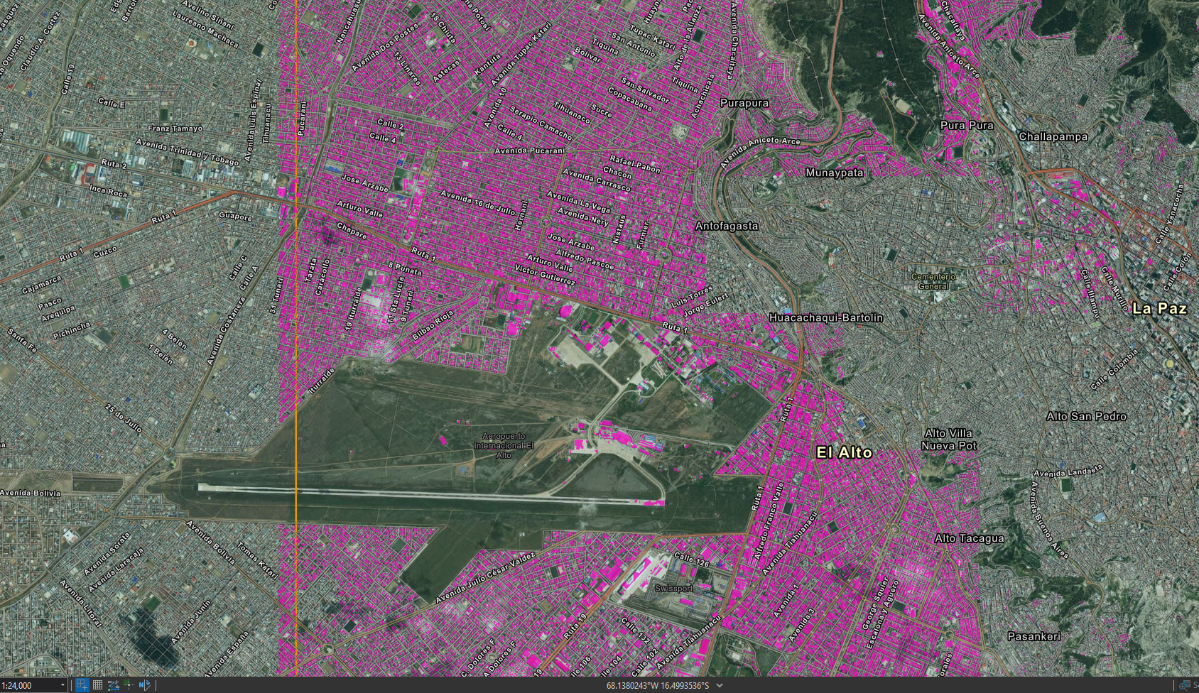
Also notice the building polygons mysteriously disappear on the boundary line between those quadkeys! This gives me an indication that the missing building polygon's aren't due to some error on the ML, but instead some error in the data processing code used to build the quadkey files from the ML results.
I went looking for the data-processing source code, but it appears to be missing from this repo. Where is the source code for this?
Contributor guide
No contributing guide indexed for this repository
First steps
- Read the whole issue, then the project's contributing guide.
- Comment on the issue to say you are picking it up — it saves two people doing the same work.
- Fork the repository and make your change on a branch.
- Open a pull request that references the issue number.
Research direction
No files or tests are named. Start by locating the repository entry point that builds quadkey files from ML results, then compare processing for quadkeys 210031332 and 210031333, especially at their boundary. Done means identifying the data-processing source and determining whether it explains the missing building polygons.
Written by the indexing model from the issue text.
Assessment
- Tech stack
- machine-learning, python
- Domain
- data-engineering, machine-learning
- Issue type
- Bug
- Difficulty
- 4/5
- Estimated time
- 3-5 days
- Activity status
- Stale
- Clarity
- Needs clarification
- Newbie friendliness
- 25/100