bSI-InfraRoom / bSI-InfraRoom/IFC-Specification
Requirements for roadway cross slope transitions in superelevated segments of roadway
- Dominant language
- No language data
- Stars
- 27
- Forks
- 24
- PR merge metrics
- No merged PRs in 30d
Description
This issue provides requirements for alternative roadway cross slope transition methods for a superelevation transition region of a roadway. See #269 discussion on Pset_Superelevation.SuperelevationTransition.
Biases: I'm a bridge engineer and I only care about alignment and roadway surface definitions in the vicinity of a bridge. I'm new to IFC and don't fully comprehend the schema.
Pset_Superelevation.SuperelevationTransition is of type PEnum_TransitionSuperelevationType. The only enumerated value is LINEAR specifying _that the transition of the superelevation between the previous superelevation event and this event shall be linearly interpolated_.
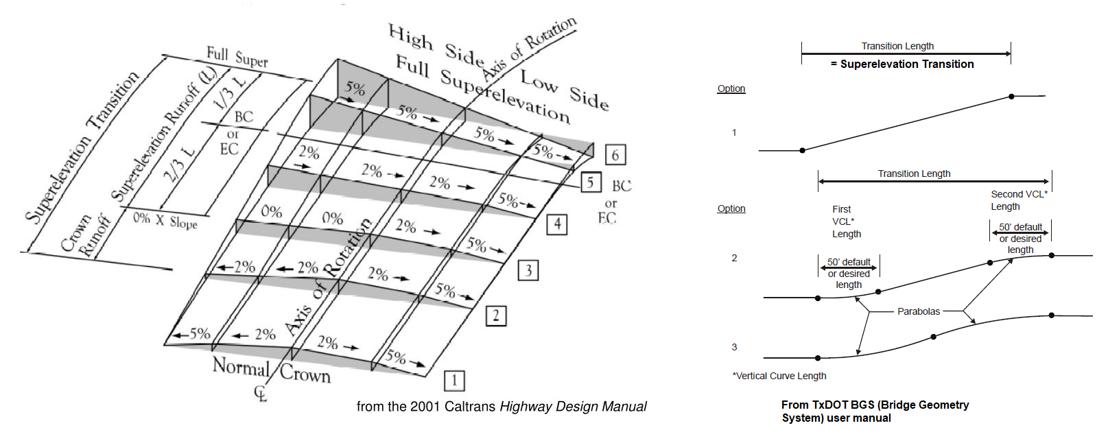
As seen in the left-hand figure in the image below, superelevation transitions occur over a range of stations. As currently specified (as I understand the specification) an instance of IfcAnnotation is required at the start of the crown runoff, the common section between crown runoff and superelevation runoff, and at the start of the full super. Each IfcAnnotation would have one or two related Pset_Superelevation where the side, slope, and LINEAR transition is specified. There doesn't seem to be a relationship that identifies the group of IfcAnnotation work together to define a superelevation transition.
The right-hand figure in the image below shows alternative methods of transitioning the roadway cross slope. The roadway cross slope is transitioned over the full length of the superelevation transition rather than between the subsets of the superelevation transition.
The right-hand figure illustrates three options for transitioning the roadway cross slope. Option 1 - Linear. Option 2 - Partial parabolic, Option 3 - parabolic.
The geometric representation of the roadway surface can be well represented by IfcSectionedSurface using IfcOpenCrossProfileDef. I understand IfcAnnotation with the Pset_Superelevation property set to be semantic information. The semantic information of a roadway cross section doesn't seem to have the same level of detail as the geometric representation.
@larswik - This is my first time developing requirements for IFC. If you need additional information, please let me know.
Contributor guide
No contributing guide indexed for this repository
Assessment
This issue has not been assessed yet.