ArduPilot / ArduPilot/MissionPlanner
Geo ref images No AMSL in CAM Messages Error
- Dominant language
- C#
- Stars
- 2.4k
- Forks
- 2.9k
- Avg merge
- 19h 16m
- Merged PRs (30d)
- 4
Description
#### Issue details
Using Here+ RTK base and rover, and camera triggering by waypoint. Using the Geo Ref tool with "CAM Message Synchro" enabled and with "Use CAM Messages" checked/unchecked (I tried both) and "Use AMSL Alt" checked, I get the following report when I click pre-process:
```
Using AMSL Altitude True
Reading log for GPS Messages in order to get AMSL Altitude
Log Read for GPS Messages
Log locations : 4233
Reading log for CAM Messages
Log Read with - 98 - CAM Messages found
Read images
Images read : 98
Photo DSC04895 processed from CAM Msg with 0 ms shutter lag. AMSL Alt NOT found
Photo DSC04896 processed from CAM Msg with 0 ms shutter lag. AMSL Alt NOT found
Photo DSC04897 processed from CAM Msg with 0 ms shutter lag. AMSL Alt NOT found
Photo DSC04898 processed from CAM Msg with 0 ms shutter lag. AMSL Alt NOT found
Photo DSC04899 processed from CAM Msg with 0 ms shutter lag. AMSL Alt NOT found
```
and so on....
However, the CAM messages in the log do show both an "Alt" and a "GPSAlt" column, both of which appear to be reporting AMSL. I'll attach a screenshot of that.
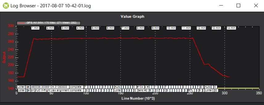
If I use the "time offset" option instead of the CAM option, things start to get pretty wonky. For example, using "time offset" with AMSL checked results in my images being geotagged with AMSL, but with one big problem: Some images (about 10%) are being geotagged with an AMSL that is very close to the RTK base AMSL, which would mean that my drone would have dropped out of the sky, hit the ground, and immediately climbed back up (if this logging by the Geo Ref tool was accurate). I've attached the graph of the GPS Alt for the flight, to show that my UAS maintained a constant altitude until it was time to land (no 100m drops in the middle of the flight). I doubt very much that the "time offset" would be a great choice for me, given this problem. Besides, the CAM messages are exactly what I need, and they have the data I need... it's just that the Geo Ref tool doesn't seem to be looking in the right place for the AMSL for CAM messages.
#### Version
1.3.49.1 Build 1.1.6417.13138 (I tried the beta just in case it had already resolved this issue, but it had not)
AND
1.3.49 Build 1.1.6410.20232
#### Platform
[ # ] All
[ ] AntennaTracker
[ ] Copter
[ ] Plane
[ ] Rover
[ ] Sub
#### Airframe type
octa
#### Hardware type
pixhawk 2.1 w/ edison installed

Contributor guide
No contributing guide indexed for this repository
Research direction
Start in Mission Planner's Geo Ref tool by reproducing preprocessing with CAM Message Synchro and Use AMSL Alt enabled. Compare how CAM messages' Alt and GPSAlt columns are read against the attached log, and verify that completed image geotagging uses the CAM-message AMSL consistently without the reported erroneous altitude drops.
Written by the indexing model from the issue text.
Assessment
- Tech stack
- csharp
- Domain
- desktop
- Issue type
- Bug
- Difficulty
- 4/5
- Estimated time
- 3-5 days
- Activity status
- Stale
- Clarity
- Mostly clear
- Newbie friendliness
- 35/100